The projects “D-A-CH Geoid” and “European Alps Geoid” – improved cross-border height determination in the region of the European Alps
“Why does the mountain ‘Zugspitze’ have two heights — when there is only one sea level?”
“How big are the differences of the height numbers between Germany, Austria and Switzerland?”
Have you ever asked yourself these questions? Or do you have to work with different height systems for a cross-border project? With our web application you can transform heights between the current national references frames of the countries Germany, Austria and Switzerland.
For scientific applications, the EVRS provides a basis for a standardized European height determination that is continuously being developed. Officially, however, the national heights still apply in land surveying. These relate to the sea level at different water gauges at different epochs, which is reflected in different zero levels (Fig. 1).
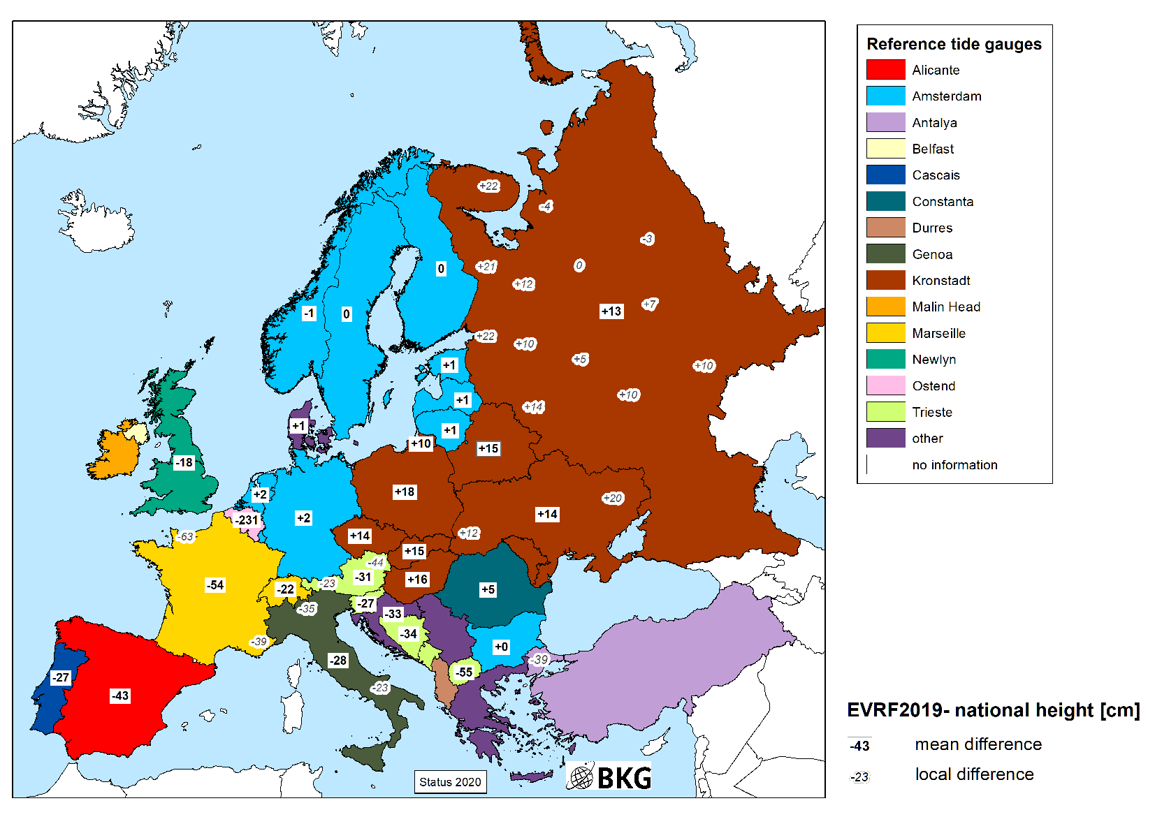
Fig. 1: Average height offsets with respect to the European Vertical Reference Frame 2019 (EVRF2019) in centimeters
Different theoretical bases for the calculation of the height information cause further local deviations along the borders (see also Fig. 2):
Example Zugspitze: 47.42112° North / 10.98623° East
| DE: | “m ü. NHN” | (Amsterdam, DHHN2016) | 2962.08 m | |
| AT: | “m ü.A.” | (Triest, MGI) | 2962.33 m | |
| Difference 25 cm |
Example Bad Säckingen (close to Laufenburg): 47.549034° North / 7.955177° East
| DE: | “H. ü. NHN” | (Amsterdam, DHHN2016) | 300.48 m |
| CH: | “m ü.M.” | (Marseille, LN02) | 300.79 m |
| Difference 31 cm1 |
Phase 1: “D-A-CH Geoid” project and test area Lake Constance
The “D-A-CH Geoid” project aims to harmonize the basis for height determination in the Alpine countries. It is a joint initiative of the federal and state authorities responsible for land surveying in the German-speaking Alpine region:
- Federal Office of Metrology and Surveying (BEV, Austria)
- Federal Office of Topography swisstopo (Switzerland)
- Federal Agency for Cartography and Geodesy (BKG, Germany)
- State Office for Geoinformation and Rural Development (LGL, Germany/Baden-Wuerttemberg)
- Agency for Digitisation, High-Speed Internet and Surveying (LDBV, Germany/Bavaria)
The Memorandum of Understanding (link in German) of October 19, 2017, aims to promote the cooperation in the field of regional gravity field modeling, to exchange and improve the underlying data and models, and to facilitate cross-border height determination for users of geodetic coordinates.
In their countries, the partners are significantly involved or responsible for determining and making available the national geodetic spatial reference. In this function, they examine the regional course of the physical height reference surface and determine the corresponding geoid or quasigeoid models for ther national territory. On the basis of these models, users of satellite positioning services can determine height above sea level with respect to the national height system.
The following work was successfully completed in the first phase (among others):
1. Improved regional geoid model in a focus area around Lake Constance
- Exchange and revision of the base data for the calculation of the geoid models: gravity data, digital elevation models, control points for validation
- Comparative studies on geoid modeling in high mountains
- Extensive comparative investigations and validation between the national height reference surfaces (geoid models and other height transformation grids) and the national and European heights along the borders
- Derivation of a consistent height transformation model for the “D-A-CH countries” accurate to a few centimeters
- Development of a corresponding web application
Fig. 2 gives an overview of the height differences along the borders of the “D-A-CH countries”.
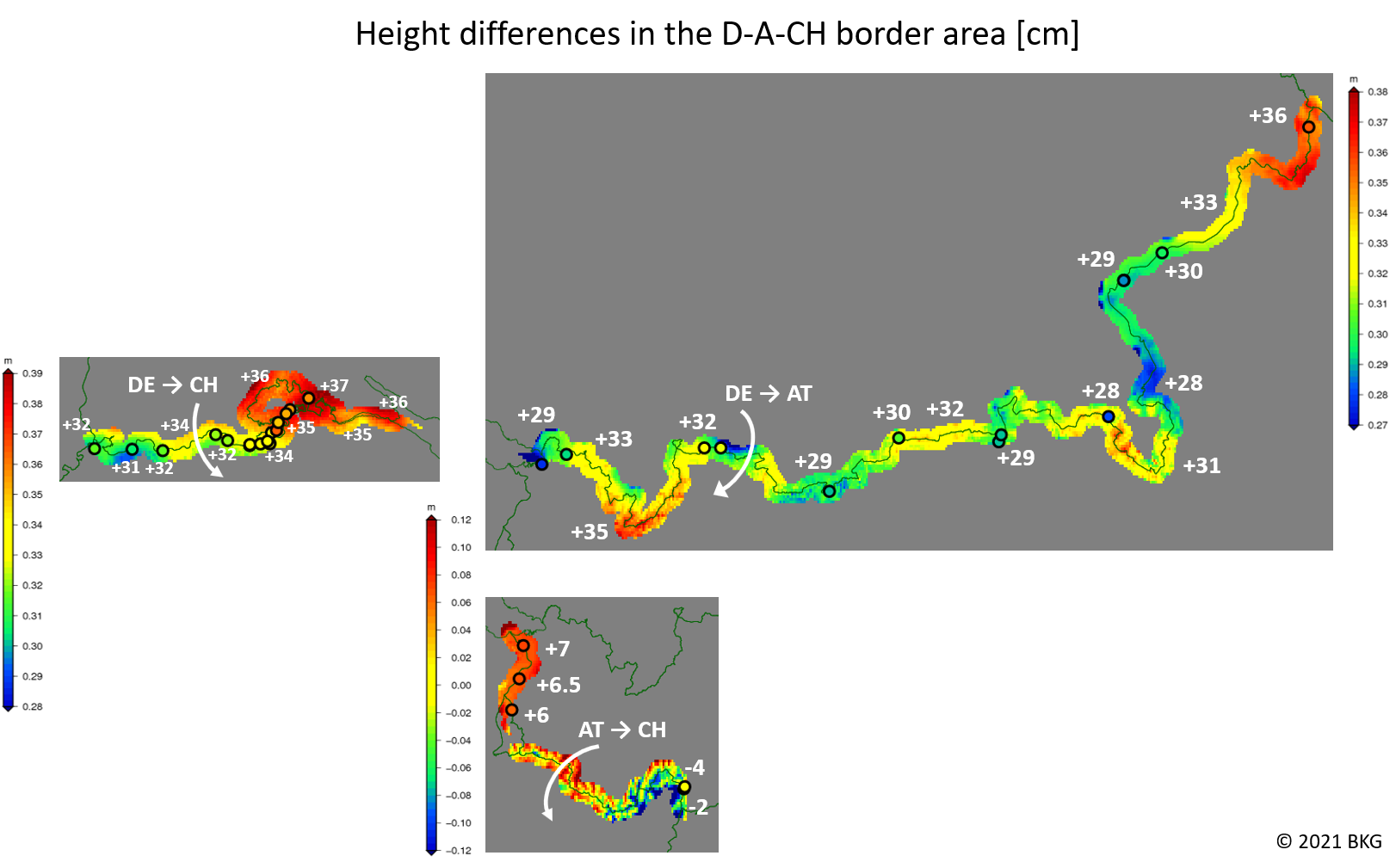
Fig. 2: Height differences between the official height systems along the borders of the “D-A-CH countries” in centimeters:
[DE] “m ü.NHN” (normal heights, realization DHHN2016, reference level Amsterdam);
[AT] “m ü.Adria” (normal-orthometric heights, system MGI, reference level Triest);
[CH] “m ü.Meer” (forced uncorrected heights, realization LN02, reference level Marseille).
The colored points indicate the exact values from cross-border leveling, the surface plot refers to the differences of the height reference surfaces (geoid models):
[DE] GCG2016; [AT] Austrian Geoid 2008+Höhengrid; [CH] CHLN02
Phase 2: The “D-A-CH Geoid” becomes the “European Alps Geoid” (ElpG)
The calculation of the height reference surface for the D-A-CH countries is not limited to the national borders. The underlying data (gravity data, elevation models) are also required for an adjacent area in the neighboring countries. At the same time, France, Italy and Slovenia also have a share in the Alpine region.
Together with the responsible national bodies for the integrated geodetic spatial reference, we are therefore currently working on expanding the initiative to the entire Alpine region and the neighboring lowlands. This means that the “European Alps Geoid” also includes parts of Croatia, Hungary, Slovakia and the Czech Republic. An extended memorandum of understanding as a basis for the cooperation is currently under preparation between the participating institutions.
The activities will as well be embedded in a pan-European initiative for a European Height Reference Surface within the framework of EUREF, the scientific sub-commission for Europe within the IAG. As a contribution to the EUREF Working Group “European Height Reference Surface”, the EAlpG will be one of many cornerstones for the first official realization of a unified European height reference surface connected to the EVRS. The metadata about the national height reference frames and transformation products will also be used in to modernize the information system for the European coordinate reference systems CRS-EU.
Background information
Modern height determination
Geodesy deals with the measurement and calculation of exact coordinates on the Earth's surface. In the past, this was done using distance and angle measurements with optical instruments, today using satellite navigation systems (GNSS), e.g. GPS,Glonass , Galileo etc. While you can determine your position to within a few meters with a handheld GPS or mobile phone, in geodesy you can achieve accuracies of a few centimeters with special techniques (for moving objects) or even millimeters (for long-term measurements).
What GPS cannot provide is an elevation in relation to sea level or the local gravity field. The spatial coordinates, e.g. expressed in geographical longitude, latitude and ellipsoidal height, relate to a global reference ellipsoid and are purely geometric.
Heights above sea level, on the other hand, are still determined by a classic method, the so-called leveling. These measurements are based on long-term readings of tide gauges and are influenced by the gravitational field. A level instrument is basically a highly accurate telescope with a sensitive spirit level. The reference surface for the height measurements, i.e., the equilibrium figure of the gravitational field in the mean sea level, is referred to as the geoid in this context.
In order to be able to use GPS for height measurements, one therefore needs a correction model, i.e., a height reference surface, which indicates the local distance of the zero level surface from the reference ellipsoid. By means of such a geoid model , ellipsoidal heights from GNSS can then be transformed into sea-level related heights.
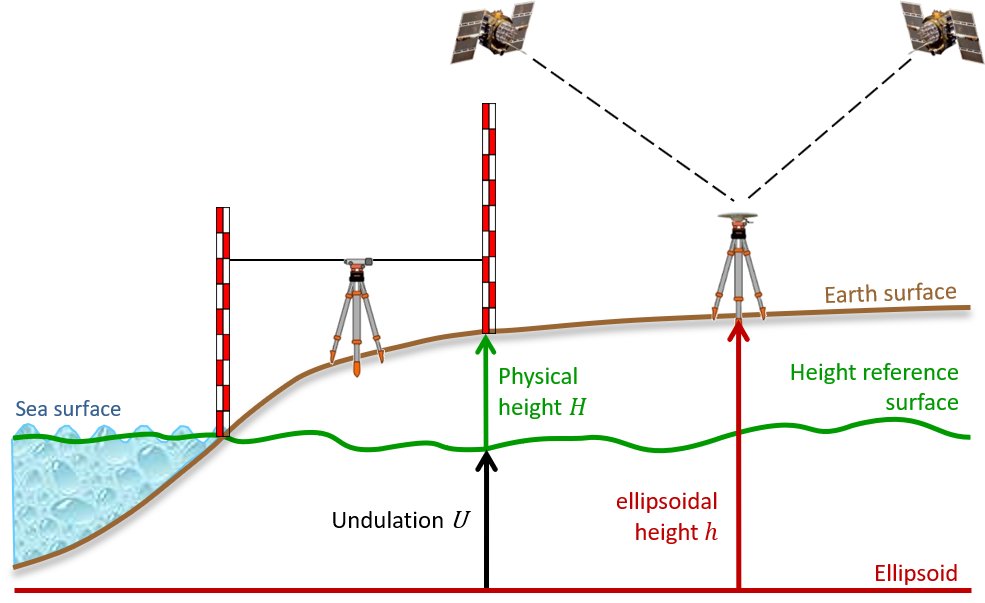
Fig. 3: Schematic overview of heights and reference surfaces. When realizing the height reference surface, differences occur depending on the definition of the actual zero level (reference level) and the definition of the height type. In general, these models are summarized and referred to under the generic term "geoid model".
“Not all sea levels are equal – why does the Zugspitze have two heights?”
The sea surface is highly variable and subject to a multitude of influences. The real mean sea level is therefore not exactly aligned with the global equilibrium figure of the gravitational field. Even in the long-term mean, it is different at every coastal location.
At the same time, countries connect their levelings to different tide gauges depending on their geographic location. The elevation value for a certain point on the Earth's surface, e.g. a mountain peak, then differs from country to country.
Simply speaking, German heights refer to the North Sea, those of Austria and Switzerland to the Mediterranean Sea (see Fig. 1 and the numerical example above).
This means that heights and the associated height reference surfaces (geoid models) are never absolute. They follow a convention (definition) for the zero level.
For example, Belgium is the only country in Europe whose heights do not refer to the mean tidal water level, but to the lowest tidal water level (Lowest Astronomical Tide, LAT).
“Why does the height difference change along the border?”
Different definitions when calculating the height information (e.g. taking into account the local gravitational field or the tides) lead to further differences. Between experts, it is spoken of height types. The height differences between individual countries can therefore also vary along the border.
With the transition of the German height reference from “Normalnull” to “Normalhöhennull” at the beginning of the 1990s, the height differences to the neighboring countries also changed slightly!
Further information can be found on the explanatory pages (standard level or expert level) of the D-A-CH transformation application.
“But there are unified European heights, right?”
The national leveling data are submitted to and processed at the UELN, depending on availability. The results are released as realizations of the EVRS with respect to Amsterdam level (NAP).
However, due to the diversity of the height networks, the EVRS is not yet as important as, for example, the ETRS89 for position determination, where all national solutions are based on the same metrological principles (satellite navigation systems). Users expect zero height to be connected to their local mean sea level.
Some countries now relate their heights to the Amsterdam level, i.e. their heights are now in principle compatible with the EVRS (e.g. Baltic States, Poland). For Germany (with the exception of the GDR) this has always been true for historical reasons.
Other countries, like Austria and Switzerland, have decided to keep the habituial height definition for end users, e.g., engineering surveys.
Literature
Rülke et al. (2013): Unification of European height system realizations. Journal of Geodetic Science 2(4):343-354, DOI: 10.2478/v10156-011-0048-1
Further references can be found at the end of the explanatory pages (standard level or expert level) of the D-A-CH transformation application.
Service