Online height transformation in the border areas of Germany, Austria and Switzerland (D-A-CH height transformation)
This service is a result of the Memorandum of Understanding about the „Cooperation for a ‚D-A-CH Geoids‘“ between
|
 |
 |
This service complements the national applications for coordinate transformation:
- [DE] Coordinate transformation (in German) | Quasigeoid height interpolator (in German) | HOETRA2016 (conversion between DHHN92 and DHHN2016, in German)
- [AT] BEV Transformator
- [CH] REFRAME
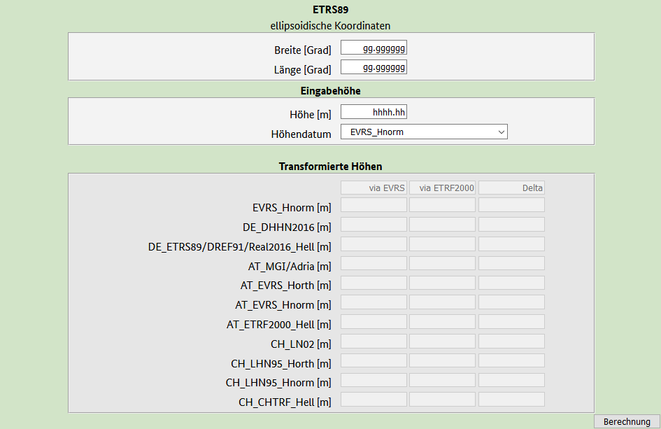
Taking into account the different height definitions (height type, zero level), heights between the the official national height systems of the countries Germany, Austria and Switzerland as well as EVRS can be transformed for individual points near the border:
- [DE] DHHN2016 („m ü.NHN“, normal heights, Amsterdam)
- [AT] MGI („m ü.Adria“, normal-orthometric heights, Triest)
- [CH] LN02 („m ü.Meer“, uncorrected heights, Marseille)
- [EU] EVRF2019 (normal heights, Amsterdam, mean-tide)
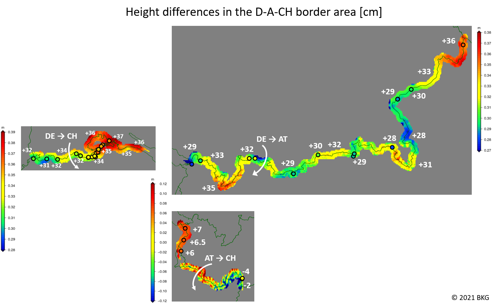
The height differences between the systems as well as their variations can be taken from the figure below.
For Austria and Switzerland, also the harmonized orthometric heights and normal heights are supported. However, these have not been introduced as official heights by the land survey offices.
The transformation from/to ellipsoidal heights measured by GNSS is also possible:
- [DE] ETRS89/DREF91/Realization 2016, epoch 2008.46
- [AT] ETRS89/ETRF2000 Austria, epoch 2002.45
- [CH] CHTRF2004 (based on ETRF93, epoch 1993.0)
Operational instructions
Mandatory input:
- geographical longitude and latitude (ETRS89, decimal degrees)
- Height in the source system
- Selection of the source system
- Selection of the target system (only in standard mode)
Due to the limited validity of the transformation grids, cross-border transformations are only output within a strip of 4 km on both sides of the border (see figure above).
The transition between different height types within a country (e.g. [CH] LN02 to normal heights in LHN95) is possible without restrictions.
The transformation paths are defined in such a way that the heights are always first converted into the higher-level European framework when applying transformation across national borders. This is followed by an inverse transformation into the target system. If possible, a DELTA value is returned as an accuracy indicator, which, in simple terms, corresponds to the inconsistency of the national geoid models in the border area.
The underlying accuracy of the data and the geoid models allows a uncertainty of the height transformation in the range of typically 1-3 cm. Consequently, the results in the web application are only displayed with cm precision.
Theoratical basis of the transformation application
More detailed information on the height systems in the “D-A-CH countries” and the transformation model can be found on the respective explanatory pages of the standard mode or the expert mode.
Further information on the D-A-CH/European Alps Geoid project can be found here: D-A-CH Geoid project site
Further information on European coordinate reference frames and transformations can be found here: CRS-EU
Important notes on historical coordinate and height reference systems in Germany
You still have to work with 2-D coordinates in the system DHDN (Bessel ellipsoid, probably Gauß-Krüger projection)?
Please first use the BKG application for coordinate transformation (in German) with parameters “GEO_DHDN” or “GK” (depending on the coordinate format) and “GEO_ETRS89” in order to point locations in geographical coordinates.
You still have to work with heights in the system „NN“ (DHHN12)?
Please first use the respective web applications provided by LGL (for Baden-Wuerttemberg, in German) or by LDBV (for Bavaria, in German).
You still have to work with heights in the current system „NHN“, but referenced to the old realization DHHN92?
Please first use the respective web applications provided by LGL (for Baden-Wuerttemberg, in German) or by LDBV (for Bavaria, in German), or alternatively the Germany-wide application HOETRA2016 (in German) provided by the Working Committee of the Surveying Authorities of the Laender of the Federal Republic of Germany (AdV).